Chinese name: UAV weather monitoring Foreign name: uav meteorological monitoring table of Contents Background introduction ·Introduction ·Industry demand UAV applied to meteorological monitoring system Implementation modalities Operation points Background Introduction Industry Profile Meteorological information is an important basis for economic development planning and agricultural development, and it is also the need for sustainable development of the country. Unmanned meteorological helicopters have their own advantages in the field of meteorological monitoring. Low-cost, low-speed, long-range, high-reliability drones perform low-altitude missions, and operators can easily control the flight path of aircraft on the ground. Flight height. The use of drone technology to carry out land and resources surveys and land use monitoring can reflect the specific conditions of various land and resources in a timely manner, enhance the foresight of resource development, environmental protection and disaster prevention, for land development and remediation, environmental and disaster monitoring, Provide basis for hydrogeology, engineering geological exploration, site selection, line selection and urban planning of construction projects. Industry demand 1. China's vast territory, meteorological monitoring and management has certain limitations on the control surface, through the existing manual methods, the efficiency is not high; 2. In terms of meteorological monitoring and forecasting, the satellite imagery is not high-definition, and it is impossible to obtain effective real-time meteorological data, and the forecasting basis is insufficient; UAV applied to meteorological monitoring system The UAV meteorological aircraft mainly measures the following meteorological data: temperature, air pressure, humidity, wind, true altitude, various images (data), cloud formation type and size, visibility, turbulence occurrence and size, and ice accretion. The basic meteorological observation accuracy requirements are as follows: Visibility: ±20% (≥0.1km, ≤10km); Cloud coverage (bottom layer): ±1/8; Cloud bottom height: ±30m (0~300m), ±10% (>300); Vertical wind profile: ±10°, ±2.5m/s; Genting height: ±150m (≤1000m), ±20% (>1000m); Ground wind: ±10°, ±2.5m/s; Ground temperature: ±1°; Vertical profile temperature: ±1°; Ground relative humidity: ± 5%; Vertical section humidity: ± 5%; Air pressure: ± 2%. For weather forecasting, the World Meteorological Organization (WMO) specifies meteorological observation elements, some of which can be measured directly, while others are subjectively estimated. Subjective estimates are detected using visible light, infrared, and microwave imagers. All equipment must be suitable for the system's choice of drones, such as weight and volume. Implementation modalities Missions typically require drones to fly on pre-selected routes. Many complex factors will affect the execution of the mission, the most important of which is the performance of the drone. There are three ways to perform a task: 1. Direct measurement. Unmanned meteorological helicopters are equipped with conventional meteorological sensors, which directly measure meteorological parameters, mainly refers to parameters such as temperature, humidity and pressure. The drone itself made a flat flight. Vertical flight and low flight can measure meteorological parameters at all levels. The aircraft often maintains a certain barometric altitude during horizontal flight. In order to make the ground meteorological data measurement more accurate, the drone must be lowered to a height of 150 meters for low-altitude flight. 2. Remote sensing measurements. With the development of remote sensing technology, unmanned meteorological helicopters will be based on remote sensing measurements. The main equipment includes wide-band infrared radiometer, wide-band microwave passive radiometer, wide-band solar passive radiometer, visibility meter and Doppler radar. Infrared detection has a high resolution and can detect temperature and water vapor distribution, but it is limited because it cannot pass through the clouds. Get the best equipment room broadband microwave radiometer with rainfall information, which can measure various cloud maps. 3. Airdrop radiosonde and data relay. Unmanned meteorological helicopters with ten aerial radiosondes are evenly distributed over an area of ​​50*50 square kilometers. The drop time is usually a few minutes. The measured data is generally relayed by unmanned meteorological helicopters. UAV weather monitoring features advantages 1. Low cost, good value for money. The cost of a drone is only a few tenths, or even a few percent, of the man-machine, and the cost of use and maintenance is low. 2. There is no risk of casualties. 3. Strong viability. UAVs are widely used in plastics, fiberglass and other wave-transparent materials for quick repair. 4. Good mobility. The small drone has a small body, is light in weight, and does not require airport take-off and landing with special equipment. Operation points Unmanned meteorological helicopters are required to fly in a variety of severe weather conditions, and data transmission systems and flight control systems may also be subject to interference. In this case, the aircraft must maintain a relatively fast speed and must accurately measure various meteorological data. Therefore, the requirements for each system of unmanned meteorological helicopters are very high. In the low-fly measurement, the drone loses contact with the ground equipment, so the unmanned meteorological helicopter must have an autonomous flight management system. Unmanned meteorological helicopters generally use navigation and wind measurement, so an accurate navigation and positioning system is required. In addition, various measuring instruments are required to have small inertia, high precision and good reliability.
It can prevent scratches and dirty fingers, and the transparent design can clearly display the screen content. The Screen Protector is easy to use and has no bubbles to maintain touch sensitivity.
The Soft Protective Film can accurately adapt to all curved screens of the Samsung series.
With a self-healing design, it can protect the display of the device from damage without leaving bubbles and maintain the sensitivity of the touch screen.
The oleophobic and waterproof coating helps minimize oil stains and fingerprints on the display.
If you want to know more about Screen Protector For Samsung products, please click the product details to view the parameters, models, pictures, prices and other information about Screen Protector For Samsung.
Whether you are a group or an individual, we will try our best to provide you with accurate and comprehensive information about the Screen Protector For Samsung!
Screen Protector For Samsung, Hydrogel Curved Screen Protector, TPU Film, Anti-Scratch Screen Protector,Curved Screen Protective Film Shenzhen Jianjiantong Technology Co., Ltd. , https://www.tpuprotector.com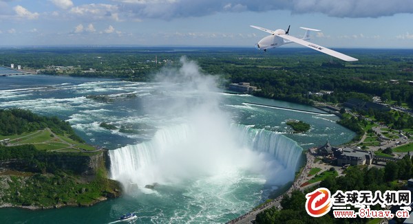
UAV weather monitoring
With the development of meteorological measurement sensors, UAV manufacturing, flight control and data processing technologies, UAV meteorological detection technology has been greatly developed, gradually matured and applied. This large-area, long-term, continuous meteorological detection method has unique functions and advantages in applications such as spacecraft launch and return, important weapon testing, battlefield meteorological measurement, severe weather monitoring, and tornado close-range environmental detection and monitoring.